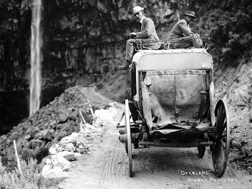
John (S) Cooper --a.k.a. Jack (on the left-Loal Hendricks on the right), was a “teamster.” This meant he could handle six big horses as they pulled a heavy wagon over dirt roads for many miles. The job took him to Twin Falls, Idaho where he hauled freight for his future father-in-law, Juel Hendricks. Hendricks was using his teams and wagons to bring freight to Twin Falls from Shoshone where the Union Pacific Railroad made a stop.
Two of Hendricks’ sons, Loal and William (better known as Ace), also drove teams. The wagons were loaded at the train station in Shoshone and traveled the thirty miles south to the city of Twin Falls, Idaho which is built near the edge of the vertical canyon of the Snake River. The only way to cross at that time was by a single lane track that switch-backed down the side of the canyon wall.
The road then crossed the canyon floor to a ferry on the river.
When Jack and his friends' wagons reached the bottom of the canyon they would race to see who could get to the ferry for the first ride across. Once across the river they drove their wagons up a narrow dug-way that was built into the lava rock walls of the south side.
It
took them all day to go from Shoshone, then down into the canyon to cross
the Snake River by ferry. When they were finally on the south side of the river
they camped for the night. The next day
they traveled the last few miles up the other side and into the town of Twin
Falls.
According to Jack’s son, Lindell, (my dad) at one point the south side road passed under the waterfall of the Perrine Coulee which dropped over the rim.
I found this photo of a freight road going down into the canyon to a ferry which crossed the river but this one was farther downriver toward Buhl and connected the Boise area to a stop on the Transcontinental Railroad at Kelton, Utah.
If the road passed under Perrine Coulee it had to be near there. I remember my dad, taking me down into the canyon to the Blue Lakes Ranch where we crossed the river and went to the south side of the canyon to see the waterfall as it dropped over the canyon rim.
I checked Google Street View. Those guys go everywhere!

The road, now called the Blue Lakes Grade, is still very narrow but at least it is paved. The sign on the right says, “Caution, yield to uphill traffic.” Note how deep and steep this part of the canyon is and now imagine driving it in a loaded wooden freight wagon behind six big horses on a road which at that time would have been just be a rocky trail.
At the bottom of the canyon is a campground. But I don’t think Jack, Loal and Ace had picnic tables and a bathroom when they stayed in this area overnight.
Now a bridge takes traffic across the river where the road starts the steep climb up the south side. The Perrine Coulee Waterfall can be seen on the upper right of this photo.
More switchbacks and now the Perrine Bridge can be seen a few miles upriver to the east. The bridge was built in 1927 and was the way my family reached the city of Twin Falls where we traveled for shopping from our farm in Dietrich, Idaho. This bridge was replaced in 1976 by a four-lane bridge.

Talk about hairpin turns! Even the Google Street View people must have had second thoughts.
This road doesn’t go right under the falls and I think the water has eroded the canyon back some since Jack drove the canyon in his freight wagon.
The road takes a traveler up the vertical rock canyon wall to the rim which is a few miles from the city of Twin Falls, Idaho.


1 comment:
Beautiful country!!
Post a Comment